Love Bank Park and Gentrification on Cherokee Street
How one St. Louis neighborhood reveals the city’s lines of race and class, but also its economic and spatial reinvigoration.
April 2, 2022
Like many American cities, St. Louis experienced a “boomtown” rise in population and prosperity during the industrial revolution of the late nineteenth and early twentieth centuries, and the steep decline that came with post-World War II deindustrialization and urban crisis. Accordingly, it has been undergoing a process of urban redevelopment and renewal over the past few decades that has vastly changed the city and called revitalization into question. St. Louis’s urban crisis happened along deeply divided lines of race and class, and so is its economic and spatial reinvigoration happening along those same lines. In many ways, the Cherokee Street district, the neighborhoods surrounding it, and Love Bank Park are unique urban arenas that reveal the pains of growth and decline in St. Louis, but they are also situated at the typical boundaries one might find in American cities of the twenty-first century.
The way that gentrification has played out on Cherokee Street in many ways emblematizes the conundrums of neighborhood change in a city like St. Louis, and simultaneously it might also symbolize the possible promise of inevitable change, if done deliberately. As such, Cherokee Street’s Love Bank Park might also represent a border zone between segregation and gentrification. It exists as a figurative outpost that simultaneously embodies the fears and fantasies of newcomers and the energy and determination that animates the traditional residents.
Cherokee Street has experienced change at a slower pace than other areas of the city, largely because of its geographic position away from the central commercial corridor. Even though the longtime commercial strip is less than two miles in length, it divides four neighborhoods, two wards, and two business districts. It runs through the communities of Benton Park, Benton Park West, Gravois Park, and Marine Villa, stretching from South Broadway on its eastern end to South Grand Boulevard on the western terminus. This means it is a commercial district that crosses many different residential communities and often finds itself at the center of battles about how the streets’ spaces should be used. In addition, business owners, community members, and groups like the Cherokee Street Non-Profit (CSNP) have all made efforts to arrest the tidal wave of transformation at some point between the typical large-scale change of urban renewal, and the economic abandonment that has plagued the area.
Even though the longtime commercial strip is less than two miles in length, it divides four neighborhoods, two wards, and two business districts.
In the past, one of the aldermen refused to allow liquor licenses on the south side of the street in order to reduce the likelihood of the area becoming an entertainment district rife with bars and clubs. This restriction was lifted long ago, and the street is now home to a number of establishments that serve alcohol, including the popular Blank Space bar and a concert venue called Foam. However, business owners and developers have consciously attempted to keep even this development on an “organic” level for at least the last twelve years.¹
Gentrification is usually discussed as a process of movement from one type of community to another, and the transformation the new community experiences as a result of this migration. Cherokee Street is unique because it represents a community that has had a long, unhurried transition, and has remained at a certain state of stability, or stasis, depending upon one’s viewpoint. And this has largely been the result of efforts of community members to allow positive economic and residential change, while preserving a sense of collective purpose. One can also see the Love Bank space as emblematic of this endeavor.
First used widely in the 1960s, “gentrification” has often come to signify something pessimistic about urban change in the twenty-first century. It indicates a process, primarily taking place in the residential housing market, by which working-class housing, and often abandoned residential and commercial buildings, are transformed into spaces attractive to middle-class residents.² Like many other gentrifying communities of St. Louis, the communities straddling Cherokee Street are all enduring the growing pains of economic change, cultural blending, and the tension of divergent preferences and priorities. Because of the efforts of some groups and business owners, it has changed over the past decade into a regional destination including an antique row, restaurants, bars, and art galleries.
Cherokee Street is unique because it represents a community that has had a long unhurried transition, and has remained at a certain state of stability, or stasis, depending upon one’s viewpoint.
At the same time, the surrounding blocks continue to suffer from poverty, delinquency, and crime, and a number of groups have formed with the purpose of improving the community and making sure recent changes do not mean long-term residents will be excluded or marginalized. This has meant that groups like the Cherokee Street Non-Profit (CNSP) and the Community, Arts, and Movement Project (C.A.M.P) have attempted to connect community residents and their children with new economic development. They have done so through planning activities and events, offering instructional classes and art programs, and creating “safe” spaces for play, gathering, and communal expression. Love Bank is one representative result of these endeavors. However, the controversy over its placement, and the complaints from nearby businesses about a perceived increase of crime in the area, make it symbolic of another aspect of a climate change in the recent evolution of the community. While Cherokee Street is becoming the “next great neighborhood,” according to Southern Living magazine, it is still dogged by questions of safety that bewilder and concern new and old residents alike.³
St. Louis tears itself apart
Many factors created the racial and economic circumstances of the Cherokee Street area and other similar districts in St. Louis. Over the past fifty years broader patterns of municipal and regional management, state decisions regarding local governance, restrictive housing covenants, and urban renewal programs shifted the landscape of the city in ways that isolated Black communities. Much like other major metropolitan areas in the country, St. Louis lost most of its population and business to edge municipalities during the post-World War II period. The growth of new municipalities accelerated in 1945 when the population threshold for “home rule,” the ability of new towns to govern themselves separate from the state, dropped to include even the smallest township. What started out as an advantage for larger cities that wished to govern their own affairs, such as St. Louis and Kansas City, turned into an emerging dilemma about the economic solvency, desirability, and centrality of the urban core in the 1950s.
Home rule effectively incentivized the formation of new towns on the urban periphery and fostered a rivalry for residents, resources, and commerce between the city and St. Louis County. As White and middle-class residents departed and commercial spaces vanished, city planners and leaders worried about the costs of continuing to service and support the “blighted” communities left behind with a dwindling tax base. This had been a growing concern since the City Plan Commission’s 1936 report, which confirmed the insolvency of tax revenue collection in consideration of tax spending in underprivileged communities. By the post-World War II period, wealthy and middle-class Whites had established many new municipalities outside of the city in order to protect themselves from the problems and costs of the crumbling urban core.⁴
While municipalities zoned themselves for particular types of development and residents, and sought to secure their demographics with restrictive covenants, jobs that formerly sustained a middle class around Cherokee Street also migrated outward. In the years between 1963 and 1976, St. Louis lost more than 35,000 manufacturing jobs while the County gained close to 165,000. As an example of a company that made the move, the Brown Shoe factory, formerly located at Washington Avenue and 18th Street, with stores and offices throughout North City, relocated to Clayton in 1952. Likewise, other firms that provided middle-class incomes and white-collar jobs to city residents found new locations in the suburbs, including Jones Pharmaceuticals, Monsanto, and McDonnell Douglas, which merged with Boeing in 1997.
This hegira of large business entities left much of South City and Cherokee Street reeling from unemployment and plummeting wages, along with many other neighborhoods across the city. In 1950, median family incomes in the areas north and south of Cherokee Street reached as high as 150 percent the median for St. Louis as a whole. This decreased to under 50 percent of the median for the metropolitan area by 1990, when the unemployment rate increased to over 7.5 percent.⁵
Along with jobs went the bulk of St. Louis’s retail and the commercial strips and public spaces they sustained. Longtime St. Louis resident Bill Keller described an atmosphere of community and commerce in the neighborhood before White flight. Working as a record store clerk on Cherokee Street from 1950 to 1955, Keller recollected various businesses including restaurants, an ice cream shop, auto supply chains, and larger stores such as Woolworth’s, Kresge, and J.C. Penney’s, all composing a major shopping thoroughfare. He fondly remembered Johnny Allen’s Watermelon Stand on the corner of Compton and Cherokee Streets, where residents would go for “[a] slice of cold melon, or an RC Cola…batting the breeze with our girl friend [sic] or buddies.” Although Cherokee Street has experienced a renaissance as a shopping, entertainment, and dining district in the twenty-first century, it previously had lost the bulk of its retail revenue, like much of St. Louis. While the city contained over 75 percent of the region’s retail sales in the late 1940s, this figure waned to less than 30 percent in the 1970s, and to only 11 percent in the 1990s. In the same period, St. Louis County’s share of regional retail increased from 15 percent to just under 70 percent. Once anchored by markets, department stores, restaurants, and emporia, Cherokee’s surrounding census tracts lost jobs, well-used public spaces, and gathering spots, all while civic leaders increasingly considered infrastructure spending and municipal funding to be burdensome, and the communities themselves unworthy of tax dollars.⁶
Unlike Mill Creek Valley, the destruction of which displaced 20,000 African Americans in 1959, major urban renewal programs spared the Cherokee Street area because of its position relatively far from the central business district and outside the path of major highway expansion. Never-theless, changes downtown heavily impacted the shape of the community. As White St. Louisans moved to the County and jobs left the city, African Americans displaced by slum clearance, highway construction, and urban renewal infrastructure projects replaced them in neighborhoods north and south of the urban core. In 1940, the populations of Benton Park, Gravois Park, and Marine Villa were more than 90 percent White along with nearly all of South City. By 1970 the area had become even more segregated, with White residents composing more than 99 percent of the population. However, the trend of racial change could be seen in four of the surrounding communities, such as Holly Hills and Carondelet, where African Americans began to make minor inroads. By the 2000 census, all neighborhoods bounding Cherokee Street had between 25 percent and 75 percent Black residents, as did many other communities in the wider area.
Racial change in the communities near Cherokee Street coincided intimately with a sharp downturn in investment and lending in the area. Between 1960 and 1975, lending in Gravois Park and Benton Park West declined by nearly 75 percent. Even more distinctly, at the far eastern end of the street, Marine Villa saw a dramatic dip of over 95 percent in lending and investing. Nearby Shaw, Compton Hill, and Fox Park likewise saw comparable slumps. In contrast, neighborhoods farther south and west, such as Bevo Mill, Princeton Heights, and St. Louis Hills, saw noticeable gains in loans and property investments. This trend is not surprising, considering those communities employed multiple successful housing covenants to maintain high property values as early as 1940. In a Federal Home Owners’ Loan Corporation (HOLC) survey in the same year, the results characterized the Cherokee Street area as ominously at risk. With “fourth grade” representing the worst residential security rating, the HOLC marked the community as “third grade,” with low median house values and in danger of a changing racial demography. This precipitated a decades-long transition from a primarily White middle-class section of South City to a segregated Black district mostly deserted by business investment, abandoned by civic leaders that found little value in its improvement, and isolated from much of the region’s job growth.⁷
There are many examples of larger-scale gentrification in St. Louis. The city has a number of communities that are experiencing, or have experienced, gentrification and demographic, economic, and racial change in varying degrees. Most of the communities that are at advanced stages of change are in, or close to, the city’s central corridor, which runs from the downtown area to Forest Park at the western edge of the city. Botanical Heights has experienced an economic rebound in the past decade, particularly because of the opening of City Garden Montessori School in 2008, which drew middle-income families to the area and significantly raised property values. Larger-scale change is taking place in the Central West End along more classical lines of gentrification. Nearby employers such as Barnes Jewish Hospital and a variety of tech start-ups in the Cortex Innovation Community have drawn young professionals to the area, changed the district’s racial composition, and increased the viability of many of the businesses. The “Whole Foods Effect,” as one St. Louis publication called it, gave the neighborhood a commercial anchor that paved the way for increased rents and the construction of luxury high-rises like the One Hundred building constructed in 2020. With 316 units with panoramic views of Forest Park, the new skyscraper demands monthly rents roughly $4,000 above average for the region.⁸
The efforts of the Cherokee Street Non-Profit Organization
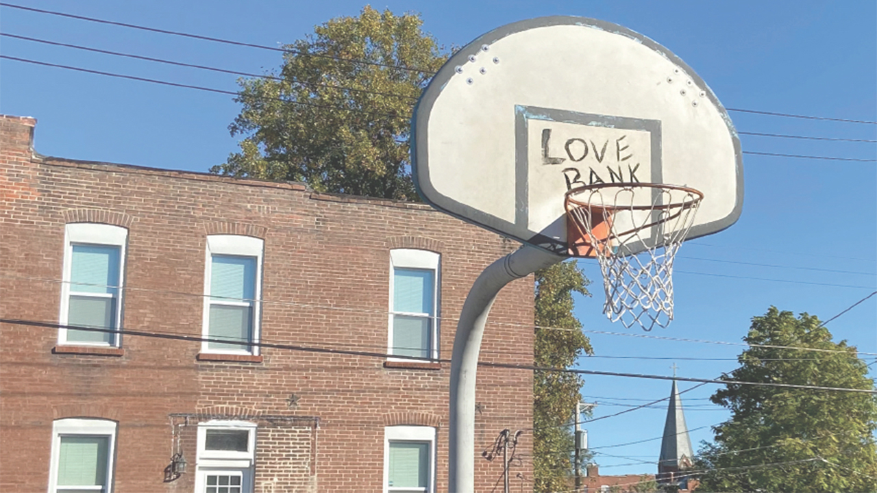
Love Bank basketball court is one of the CNSP’s most notable efforts at tempering the advance of change on Cherokee Street, and it also serves as a symbol of their philosophy on how to deal with neighborhood transformation. In my conversations with Cherokee Street liaison and CNSP leadership member Anne McCullough in 2017 and 2018, she made it clear that the organization is committed to finding ways to defend the community from outsized construction and corporate investment and keep longtime residents of the area that surrounds the street integrated into any new development. In 2011, the Cherokee Street Business Association (CSBA) hired McCullough as its director and tasked her with managing projects, events, and public activities in the area, and fostering growth and development there by assisting business owners with “anything they need[ed].” Along with Will Jones, who is also involved with CNSP, McCullough came up with the idea to place the basketball court at the corner of Nebraska Street and Cherokee in order to serve the large number of kids under the age of 18 in all of the neighborhoods that surround the district. The organization did not go to the neighborhood association for approval or request funding from the city but used some of the non-profit money to put in the hoop themselves in what McCullough calls “DIY urbanism.”⁹
Alongside these efforts to avoid displacing long-term residents, changing demographics and new businesses have conspicuously altered the image of the Cherokee Street area, and local and national publications have characterized the business revival as a triumph for St. Louis. The street itself is considered a down-to-earth, yet chic and modern, up-and-coming food district. In Feast magazine’s 2015 “Food Lover’s Guide to Cherokee Street,” writer Sarah Fenske called it “the hottest thoroughfare in St. Louis” filled with businesses “serving the young and hip.” Addressing popular concerns about crime in the area, Fenske reassured readers that a trip to Cherokee Street should be safe and easy. “Sure, the surrounding parts of South St. Louis can be gritty, but business owners … are friendly,” she implored. “Don’t be intimidated.”10
However, safety has been a primary concern of many of the neighborhood’s new and old residents. Business owner Francis Rodriguez embodies the dichotomous relationship between longtime residents, new development, and the tension about security in the community. After nearly fifty-five years living in the area, he opened a wood-fired pizzeria called “Yaqui’s” in 2014. Since its opening the eatery has not only drawn customers from the broader St. Louis region but has also served as a community venue and a space for political expression. Cinco de Mayo partygoers destroyed a piñata in the image of President Donald Trump in 2017, and local politician Bruce Franks Jr., celebrated his Missouri House of Representatives win at Yaqui’s. Rodriguez is also one of the most vocal critics of crime in the district and has occasionally pursued “purse-snatchers” and other offenders in public, and carried a handgun for self-defense, according to newspaper reports.11
Beyond basketball, the Love Bank has also become an interesting open town-square-like space where new and old community members come together, and where people from different racial and economic demographics converge.
Many Cherokee Street proprietors agree with the mission of the CSNP and are happy the basketball court provides kids a space to feel included in the area, but a number of other business owners in proximity to the court have complained about its presence so close to their establishments. Unfortunately, a number of other business owners in proximity to the court have complained about its presence so close to their establishments. Some have questioned whether or not a play space for kids is appropriate in the middle of a business district and suggested they use other parks in the area for recreation. Businessowners have likewise complained about a spike in crime, one they associate with the teenagers attracted to the area by the court, citing petty theft and possible harassment of customers. Although there have been some incidents and misdemeanors, McCullough argued they did not indicate the park was the cause of the problem. “There has not been any criminal activity at the park,” she says. “No one has been arrested.” Instead, there has been “an issue of ownership over the park,” which created tension between those who actively use it and those who see it as a nuisance. “Certain community members feel ownership,” she concluded, and others “actually reject ownership.”12
Tension in the community flared in light of the gruesome beating of a White couple in nearby Gravois Park in September of 2016. A few adult women and a large group of teenage boys allegedly assaulted Emma and Rob Ludwig after they attempted to intervene in what they saw as inappropriate treatment of a teenage girl. This incident elicited headlines such as “Roving groups of kids making life miserable in Gravois Park” from the St. Louis Post-Dispatch, among others. A month earlier, an assailant badly assaulted Cherokee Street business owner Huan Le during a robbery, leaving him with injuries from which he later died. In the six months between August 2016 and February 2017, Gravois Park saw an increase in crime of 8.5 percent, including a jump from 71 violent crimes in the previous six months to 132. A neighborhood at the eastern end of Cherokee Street, Marine Villa, experienced a similar increase with 10.2 percent more crimes reported in that six-month period, and an increase from 34 to 54 violent crimes. Many of these communities are also speckled with abandoned properties, clustered sometimes three or four on a block. A 2017 survey by building inspectors determined that Benton Park, Benton Park West, Gravois Park, and Marine Villa had 389 vacant buildings altogether. While these statistics certainly do not prove that Love Bank is increasing the risk of crime for surrounding businesses, they do indicate that this section of South St. Louis is still experiencing many of the instabilities characteristic of economically deserted communities that lead to questions about safety and the meaning of revitalization.13
Despite continuous questions about security, since the court’s installment it has become a very popular space for neighborhood kids to spend their time, play basketball, and participate in other events. CSNP and the Love Bank Park Committee have organized basketball tournaments with teams sponsored by local businesses, which they hoped would begin to bridge the emerging gap. Beyond basketball, the Love Bank has also become an interesting open town-square-like space where new and old community members come together, and where people from different racial and economic demographics converge. Other organizations from surrounding neighborhoods have held festivals—centered around activities for children in the park—which have proven popular. Gatherings around bonfires, free documentaries shown by anarchist groups, and debuts of music videos from local hip-hop artists have all taken place there.14
As the director of the CSBA, McCullough saw the usage of the park as a DIY triumph but envisioned other plans for it. In thinking about how to make the park grow she was concerned about making sure the kids who used it would continue to feel comfortable in the space. Looking to expand the space, the CSBA bought an adjacent lot in 2017 from the city for only the cost of closing fees. The CSNP also received a $170,000 grant from the Metropolitan St. Louis Sewer District (MSD), which will allow the upgraded and expanded park to have sustainable stormwater management components and a porous asphalt court, the first-ever in Missouri. The new court will not only permit more efficient drainage of water but is better on the knees, and noticeably quieter. McCullough and CSNP are also interested in meeting the needs of all the neighborhood’s residents and businesses while remaining thoughtful about changing the feel of the community. “It makes me nervous when I show the plans [for the new court],” McCullough explained, “because I don’t want people to feel left out, and I don’t want it to look so shiny and new that it just feels like a park that isn’t a safe space for everyone.” Future plans include hiring someone to manage the court, spend a lot of time on site, clean up, and check in with the kids. That person will likely have some security capacities but will purposely not be a security guard.
Looking at neighborhoods in economic transition, it becomes clear that the interaction between diverging interests, particularly among old residents, new residents, and business owners, is defined by the fact that those entities exist on the edges of racially, economically, and socially different spaces.
As such, the basketball court not only invokes reflection on the geographic boundaries that sit between economically deserted spaces and those that are revitalized by new investment and new residents, but it also calls forth questions about how development should play out. Looking at neighborhoods in economic transition, it becomes clear that the interaction between diverging interests, particularly among old residents, new residents, and business owners, is defined by the fact that those entities exist on the edges of racially, economically, and socially different spaces. On the one hand, there are those residential spaces in communities that are still affected by decades of disinvestment, White middle-class flight, and poverty, and on the other are newly refurbished commercial spaces and housing that are meant to cater to the tastes of new arrivals. In St. Louis, these realms converge on Cherokee Street, and the emerging amenities, including restaurants, bars, gardens, and the basketball court itself appear as nodes in which tensions, fears, concerns, and community materialize.
Continuing to develop spaces like Love Bank is essential to Cherokee Street’s future, according to McCullough. When asked what she hopes to see as the area evolves, she said she would encourage business owners to understand their part in the collective aspects of the community: “I would want for stakeholders to continue prioritizing the social development of the area in conjunction with or above the economic development of the area.” Cherokee Street has a lot of challenges to contend with in order to maintain a sense of equilibrium that would foster the sort of growth that McCullough wishes to see. However, Love Bank is a decidedly robust symbol of a community-wide sentiment of collective purpose.15
1McCullough, Anne. Interview by Douglas Flowe. Personal Interview. St. Louis, Mo, Feb. 6, 2016.
2 Neil Smith and Peter Williams, Gentrification of the city (London: Routledge, 2010) 1-2.
3 Stephanie Granada, “Next Great Neighborhood: Cherokee Street in St. Louis,” Southern Living, accessed Oct. 20, 2017, http://www.southernliving. com/travel/next-great-neighborhood-cherokee-street-in-st-louis
4 Colin Gordon in Mapping Decline: St. Louis and the Fate of the American City (Philadelphia: University of Pennsylvania Press, 2008) 39-40. Information on taxes on 64.
5 Gordon, Mapping Decline, 39-40; Statistics on manufacturing job loss and growth taken from Gordon, 17, 20. Information about the Brown Shoe Company found in “Brown Shoe Company Through the Years,” St. Louis Post-Dispatch, April 16, 2015. Unemployment rates and median family income percentages, Gordon, 18, 36-37.
6 Bill Keller, “A Bit of Cherokee Street History,” The Cherokee Street News, Jan. 4, 2016, accessed October 20, 2017, http://cherokeestreetnews. org/a-bit-of-cherokee-street-history/; Colin Gordon’s map in figure I.5 indicates that even while St. Louis City’s share of regional retail sales decreased over a nearly sixty-year period, outer Missouri counties’ shares grew in addition to those of St. Louis County. Between 1940 and 1997, counties bordering St. Louis County increased retail sales from less than 5 percent to nearly 12 percent. Gordon, Mapping Decline, 21.
7 Information on the statistics of South City neighborhoods taken from maps showing color-coded racial demographic change in St. Louis
and the County. Gordon, Mapping Decline, 31-34; Statistics on the decline in lending on 108. Maps of Home Owners’ Loan Corporation’s residential security ratings on 95.
8 “The Whole Foods Effect and the Central West End,” NextSTL, October 23, 2012; and “Luxury on the Rise,” St. Louis Business Journal, Oct. 22, 2020.
9 Ibid.
10 Sarah Fenske, “A Food Lover’s Guide to Cherokee Street,” Feast Magazine, April 8, 2015.
11 Nicholas Phillips, “As Cherokee Street Faces Its Future, Crime Remains a Major Concern,” Riverfront Times, June 7, 2017.
12 Ibid
13 “Victims in Gravois Park Beating Question Police Response,” Riverfront Times, Nov. 10, 2016; “Shopkeeper beaten and robbed near his Cherokee Street business is in critical condition,” St. Louis Post-Dispatch, October 25; “Storekeeper Dies Following Brutal Beating and Cancer in St. Louis,” STLToday, March 4, 2017; 2016 Statistics on crime found on St. Louis Today, St. Louis Crime Tracker.
14 Ibid.
15 Ibid.