Delmar Boulevard
Segregation in concrete.
April 2, 2022
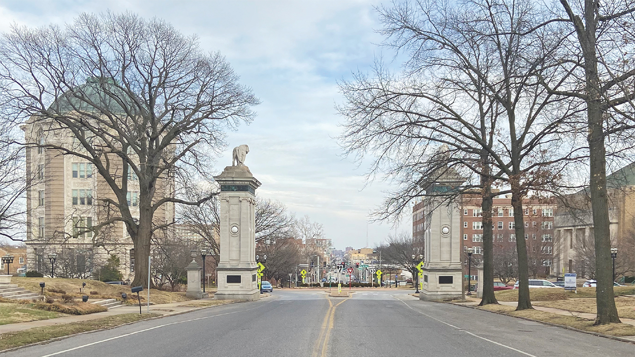
Delmar Boulevard—originally known as Morgan Street—marks a sharp crease across St. Louis’s racial geography. Running in a line west from the city’s historic core on the Mississippi levee to a quiet terminus at Price Road in St. Louis County, the street has, for nearly a century, provided St. Louisans with a convenient marker by which to fix the separation between perceived “Black” and “White” neighborhoods. The perception is, as we will see, well-grounded in reality. But it survives as much for its utility as for its accuracy. It serves the interests of those who would see segregation as a geographical fait accompli—a condition that impels, rather than reflects, human choice, a barrier concealing not just other neighbor-hoods but (to paraphrase the activist and social critic Michael Harrington) “another America,” out of both sight and mind.
In the context of other, more localized subjects in this volume, a ten-mile strip of concrete—one whose two ends might as well be (and in fact are) in different cities—makes for a pretty diffuse “site.” While Delmar possesses a definable and continuous material identity (to borrow the old joke, “This road don’t go nowhere; it stays right here”), we do well to remember that a street obtains its identity as much by the places through which it passes, the distinctions that it defines on either side of it, and the movements that it enables as it does through characteristics that inhere to itself. Delmar is, to St. Louisans, one site and many—but all of them bear the weight of a shared assumption about racial division’s inevitability and, in the process, freight a public right-of-way with the power to affect and then maintain conditions that, in truth, derive from a sequence of human decisions and accidents that might have resulted in different ends or made themselves known in different places.
How did this particular path of concrete and asphalt acquire its out-sized status as a social and racial barrier? Other local streets likewise lend themselves to quick associations among St. Louisans—Lindell Boulevard connotes wealth, Gravois Road death, St. Charles Rock Road automobiles. Like those long and well-traveled roadways, Delmar has a particular story that owes as much to geographic and historical circumstance as it does to the conscious effort of residents or investors. Before anything else, these streets reflect the lay of the land on which they are built. But once established, they materialize the connections and separations between people, worksites, and institutions that will, in turn, alter the city’s history. In them, the palpable contours of place materialize and then naturalize the invisible workings of human will.
In the context of other, more localized subjects in this volume, a ten-mile strip of concrete—one whose two ends might as well be (and in fact are) in different cities—makes for a pretty diffuse “site.”
Let us look back, then, at that historical interplay between the lay of the land and the laying of human plans—first, in the period leading up through White real estate agents’ effort to pass a citywide residential segregation ordinance; then in the mid- to late-twentieth century, when segregation proved its ability to endure without the aid of explicit public regulation. These historical episodes help us to understand the street’s acquisition of a distinct social, then racial, identity. Finally, they shed light on our own historical moment, when the Delmar divide once again attracts attention, this time as the site of opportunity to model integration in a city that has shed many of the historical determinants of its physical and social profile.
I.
The selection of Washington Avenue as the site of the Missouri anchorage of the Mississippi River (Eads) Bridge, which opened for traffic in 1876, sealed that street’s identity as the city’s principal retail and (further west) wholesale thoroughfare. (FIG. 1) Lucas Avenue, one block north, provided a kind of service alley to Washington’s substantial new buildings. As tall warehouses, stores, offices, and government buildings dominated the downtown streetscape from there south, the blocks north—commencing at Morgan Street—provided room for the overflow of tenants unable to compete with rising central business district land values. Morgan was less important in itself than it was as the back door to the quickly forming downtown. No equivalent southern access existed; instead, the streets south of the central business district were separated, first, by the creek that wound through low-lying land south of the village, then by the mill pond that replaced it, and finally by a cordon of railroad tracks that in the 1840s took the place of the drained pond.¹

In effect, then, Morgan Street early marked one boundary of what appeared to both residents and visitors, by 1900, a trifurcated city: the South Side stretched from the tracks to the city’s eventual southern boundary line on the bank of the River des Peres, which finds its outlet to the Mississippi in the former village (now neighborhood) of Carondelet; the North Side northward from a line described by Morgan. The central corridor—with its concentration of residential and commercial wealth and public power—occupied the space between. As the city spread from its original waterfront blocks, each section acquired its distinctive character. To the south settled German and Central European immigrants, first in neighborhoods crowded with two- and four-family flats and alley-facing dwellings along the industrial and commercial belt that paralleled the waterfront along South Broadway, then further inland in neighborhoods of detached homes and flats, groceries, and saloons, interspersed with commercial streetcar routes such as Jefferson Avenue and Cherokee Street. In the central corridor lay the city’s most densely built neighborhoods, typified by close juxtaposition of poverty and wealth. Consider the social gap between exclusive Lucas Place (a remnant of which survives today in the Campbell House Museum) and nearby streets like Targee (site of Frankie Baker’s 1899 murder of Allen Britt—an episode quickly transformed into the song “Frankie and Johnny”). North of Delmar, still accessible to the city center but clearly separated from downtown business or silk-stocking residential districts, lay the most diverse and representative third of the city. North Side neighborhoods were Irish or German, Polish Catholic or Russian Jewish, poor or middle class. In short, they looked like the increasingly diverse city of St. Louis. (FIG. 2)

Because of this diversity, and because of its geographic continuity with the central corridor, the half of the city that lay north of Morgan Street was slower to acquire a unified identity as “North St. Louis” or “the North Side” than was its cross-town counterpart, known from early days as South St. Louis. South St. Louisans had clear political champions—men such as the Democrat Henry Ziegenhein, elected mayor in 1879 following a strongly sectional campaign based on his call for public improvements in the city’s more remote neighborhoods—while the North Side simply offered public officials who appealed to the range of ethnic and political loyalties among the urban electorate.² The North Side’s infrastructural connections to the central corridor enabled it to develop more quickly than the south; its western reaches built up far more quickly than those in the south (where some areas within the city limits did not develop until after World War II); and its neighborhood populations cycled more rapidly out of older neighborhoods and into newer ones.³
This is, like most American city stories, a story about race. But turn-of-the-century St. Louis, for all of its explosive growth and expanding immigrant population, was not a notably racially-diverse place. The 1900 census recorded some 35,000 African Americans in St. Louis—a substantial community in absolute terms (larger, by way of comparison, than the total population of any city in Mississippi at the time)—but they were only six percent of the more than 575,000 people living in this fast-growing city. Other border cities, similarly situated in former slave-holding states at the edge of the rural South, had proved more welcoming. Baltimore, a city of roughly 75,000 fewer residents than St. Louis, housed more than twice its number of Black citizens. Louisville’s Black population comprised nearly 20 percent of that city’s total. Only after the advent of the First World War and the First Great Migration did St. Louis’s racial proportions begin to shift substantially. The 1920 census classified more than one in ten of the city’s three-quarters-of-a-million residents as “Negroes”; that percentage would continue to increase in the decades that followed, particularly with the 1924 passage of federal immigration restrictions, which slowed the influx of southern- and eastern-European immigrants to St. Louis and other American cities, and the disproportionately White outmigration to the suburban towns of a politically separate St. Louis County from the 1920s forward.⁴
This is, like most American city stories, a story about race. But turn-of-the-century St. Louis, for all of its explosive growth and its expanding immigrant population, was not a notably racially-diverse place.
When Black St. Louisans had comprised a small minority, their presence remained scattered among a handful of isolated, semi-rural settlements, such as the outlying north-side community of Elleardsville (better known as The Ville), and the highly urbanized blocks on either side of the Mill Creek Valley, where industrial employment for unskilled laborers lay near at hand. For African-American families moving in from rural Missouri and points south, crowded Mill Creek streets such as Chestnut and Pine provided an opportunity similar to that offered by the aging neighborhoods north of Morgan—particularly in the vicinity of Biddle Street—to incoming Eastern European Jewish families: cheap housing, proximity to other families similarly challenged by the city’s majority-dominated cultural institutions, workplaces, and sources of financial and social support. (FIG. 3) Each area was, in other words, a ghetto—but also a site of opportunity and solidarity, so long as the city’s economy grew and opportunities for better housing and work remained for those who made it through the first steps of assimilation.⁵

Those opportunities did not, however, make themselves equally available; neither did the fate of these neighborhoods match one another as the African-American population grew. Among the many historical differences between St. Louis’s European-immigrant and African-American populations, a vital geographic distinction marked their relative progress in the early twentieth century and contributed to the rise of Morgan Street/Delmar Blvd.—a street located midway between their respective core neighborhoods—as a citywide marker of racial segregation from the 1910s forward. The Mill Creek Valley lay due west of downtown, in St. Louis’s version of what geographers call the “zone of transition”—the area of a city that sees the most direct effect of population and economic growth, both in the form of “discard”—that is, buildings aging to the point that their owners choose first to neglect, then to destroy them—and of “assimilation”—their replacement by more profitable uses.⁶ It was in this swath that housing and businesses would be cleared to make way for the site of the city’s Union Station in 1891, of the new City Hall in 1893, and, most ambitiously of all, of the scheme known as the Central Traf-fic Parkway, which required condemnation and public purchase of a great number of city blocks for the widening of Market Street and maintenance of a landscaped parkway beside it.⁷ The parkway, a favored scheme of the elite membership of the St. Louis Civic Improvement League, was rejected by city voters in 1915, but it gained new life as an element of the city’s major bond issue of 1923. While the actual project was subject to another three decades of work, the continuous pres-sure of condemnation and demolition on Mill Creek housing from the parkway’s inception, in the 1910s, forward meant that the neighborhood’s residents were forced to move. (FIG. 4) They did so, first, due west, in the direction of Grand Avenue, and then, following the massive clearances authorized by the 1949 and 1954 Housing and Urban Renewal Acts, out of the central corridor altogether. The South Side, long separated from this area by the industrial belt that had replaced the old Mill Creek and relatively insulated from the urban discard phenomenon, proved a difficult place for St. Louis’s Blacks to settle. In addition to whatever resistance they faced from their South Side German-ethnic neighbors, their settlement in the city’s southern half was also retarded by the slowness (relative to their North Side counterparts) of South Side builders to develop outlying neighborhoods—neighborhoods that might, by offering attractive housing opportunities to upwardly mobile residents of older, more central areas, open entry-level housing opportunities to others.

Morgan Street—the North Side’s back-door entry into the central corridor—was the most obvious marker of pressures for social and racial transition. Consider the arrival and departure of two of the street’s best-known residents: writer Kate Chopin, daughter of a well-off Irish/Creole family, who lived in the 3300 block of Morgan from 1886 until her departure in 1903, and Scott Joplin, the African-American musician who moved from his home in western Missouri to a house on the street’s 2600 block in 1902. (FIGS.5, 6) By the new century’s second decade, the presence of a growing population of Black families, like Joplin’s, within the increasingly confining geographic limits of the Mill Creek, made either integration or, more likely, a newly-drawn line of implicit segregation seem inevitable to White St. Louisans who had come to think of the over-full Mill Creek Valley as the logical home to most of their African-American co-citizens. Yet those White St. Louisans, especially along the Morgan Street corridor, were disinclined to trust in implicit rules in a moment of unpredictable transition.⁸ They moved toward more explicit means for maintaining the separation.
Morgan Street—the North Side’s back-door entry into the central corridor—was the most obvious marker of pressures for social and racial transition. Consider the arrival and departure of two of the street’s best-known residents: writer Kate Chopin, and Scott Joplin.
St. Louis’s 1916 segregation ordinance was, to its supporters, simply another example of the progressive governance that they had promoted for years through civic-minded volunteer groups, such as the Civic Improvement League and the Wednesday Club, and through anti-corruption efforts, such as those revealed by muckraking reporter Lincoln Steffens in the pages of McClure’s magazine.⁹ The ordinance was birthed in reformers’ efforts to use popular initiatives and referenda to battle legislative corruption. In 1914, the city’s voters passed a new charter empowering citizens to petition directly for the aldermen to place referenda on the ballot. The following year, the St. Louis Real Estate Exchange—the city’s professional organization of real estate agents—formed a subgroup, the United Welfare Association (UWA), for the purpose of drafting and promoting the city’s first initiative: a proposal for a segregation ordinance, along the lines of those already passed by legislators in Baltimore (1910) and Louisville (1914).10

White developers had employed racial restrictions in their subdivision covenants since at least 1911 (roughly the moment at which both the Great Migration and the pressure to redevelop the Mill Creek area began to make themselves felt), but the idea of applying citywide law to effect what landowners were otherwise left to patch together on their own gave real estate dealers a tool—not unlike land-use zoning, which was working its way through the city’s legal system at the same time—for making property sales more predictable and, they believed, profitable.11 The segregation ordinance, like the first zoning code, proceeded from the assumption that the second of those two qualities followed from the first. Realtors reasoned that what had come about in the unregulated city reflected natural tendencies—and that the city’s success demanded careful stewardship of those trends into the future. Racial composition was, according to this logic, one more factor—like industrial occupancy, or multi-family vs. single-family development—in determining the investment risk in a given district. The presence of a plurality of Negro residents was not a positive or negative factor in itself, according to this reasoning; the uncertain possibility of turnover from White to Black was. For this reason, the UWA drafted an initiative aimed at “preserving peace, preventing conflict and ill-feeling between the white and colored races,” which forbade residents of either race to move to a block on which a “major portion of feet frontage are, in whole or in part, occupied or used by” members of the other race.12
In January 1916, a majority of the members of the city’s Board of Aldermen approved the petition seeking an election on the segregation ordinance. Over the coming months, as the referendum approached, the UWA and its supporters used public meetings, interviews, and news releases to frighten White homeowners into supporting the proposed law. That fear acquired a specific geographic cast, one pertinent to our study: in a flier titled “Do You Realize this Danger, Your Danger?” segregation advocates included a list (with home addresses) of “a few of the many people who have lost considerable money due to negro invasion”—more than 30 of them residing in the 3900 and 4000 blocks of Morgan. (FIG. 7) In one of its series of “Segregation Talks,” published in the Missouri Republican in the weeks leading up to the vote, the UWA pointed out “Where the Negro Districts Are,” explaining that “one of the chief centers of negro population is on Morgan and adjacent streets just north of the business section, extending westward from Eighth Street to Ewing Avenue,” where it met with “the Market and Pine Street negro district”—that is, the Mill Creek Valley, west of the site of the clearance and downtown expansion already underway. A UWA flier supporting the measure displayed the homes on the 4300 block of West Belle Avenue (four blocks north of Morgan) as “one of the many blocks that have depreciated more than 50% by Negro Invasion.” Realtor Charles P. Bradley, explaining to a Republican reporter that “the colored people, while hard workers as a rule, are generally neglectful of the property they occupy,” singled out Morgan Street, along with Finney Avenue (an east-west street lying seven blocks north) and Fairfax Street (which lay midway between the two), as prime examples of the changes underway. Augusta Boaz, a resident of the 1300 block of Walton Avenue (six blocks north of that street’s intersection with Morgan) who favored the new law, told the newspaper that because new Black residents on her block were “spoiling” her home’s value, she “went to the negroes and told them they were unwelcome.”13 Despite occasional references to South Side streets, the UWA clearly concentrated its efforts on Morgan Street and its neighboring blocks to the north, where the anxiety of realtors and White homeowners over the impact of turnover in the Mill Creek Valley promised to translate into strong election-day support.

The measure passed overwhelmingly. Some 80,000 St. Louisans went to the polls on February 29; more than 52,000 of them endorsed the ordinance. “No” votes prevailed only in the city’s Fifth, Sixth, and Seven-teenth Wards—the aging central neighborhoods, just south of Morgan, that shared both the highest concentration of Black voters and the greatest need for new housing opportunities. Augusta Boaz’s Twenty-Sixth Ward neighbors endorsed the ordinance by a margin of more than four to one; other North Side wards, particularly in the newer neighborhoods further west, voted similarly.14 “North St. Louis,” a descriptor that had, to this point, made geographic but not social sense, at last began to acquire a political and demographic coherence, born of resistance to racial change. And Morgan Street—known after a massive 1933 widening and repaving project as Delmar (the name derived, appropriately, according to local lore, from neighboring landowners hailing from Delaware and Maryland, two states that shared a boundary along the historic line between slavery and freedom)—had acquired its place as a marker, first of White resistance and eventually of White desertion.15
The segregation ordinance—unlike the successful zoning ordinance that followed it in 1918—died in the justice system: an April 1916 US District Court of Appeals injunction prevented its local enforcement; then, more definitively, the US Supreme Court’s decision in the Louisville-based Buchanan v. Warley case found legislated segregation in violation of the Fourteenth Amendment. The realtors’ effort to equate the shade of human skin with other regulatable forms of land use had failed in the courtroom. It would survive in the marketplace.

II.
The impact of continued racial turnover upon the central corridor and near North Side manifested itself clearly enough without the benefit of municipal regulation. With Blacks seeking residential opportunity outside the Mill Creek Valley, dozens of subdivisions north of Delmar passed racial covenants that bound homeowners to selling only to White purchasers. It was one of these subdivisions whose covenants would be declared unenforceable in the landmark 1948 Shelley v. Kraemer decision.16 The City Plan Commission, taking advantage of New Deal funding to undertake its comprehensive survey of real property in the 1930s, documented the level at which racial separation had taken hold without the benefit of the ordinance. (FIG. 8) The commission’s undated map, drawing on 1930 census figures, shows one-third of the city’s total “Negro population” confined to a single census tract: the 21st, bounded by Market Street (nine blocks south of Delmar) on the south, Cass Avenue (eight blocks north) on the north, 18th Street on the east and Grand Boulevard on the west. Another third of the city’s total Negro population lived in Tract 11: from Delmar north to St. Louis Avenue (the principal commercial thoroughfare of the historically Black Ville neighborhood), and from Garrison Avenue west to Marcus Avenue (a block east of the contentious Walton Avenue). Tract 11 was, by 1930, a hypersegregated district: 93 percent of its residents were African American. By contrast, the map showed adjoining Tract 19, commencing on the opposite side of Delmar and continuing south to Laclede Avenue, and from Grand Boulevard west to Taylor Avenue, with a Black population totaling under 6 percent of the district’s total. The Plan Commission further annotated its map with notes marking the boundaries of the St. Louis Real Estate Exchange’s “Negro Districts”—those zones to which the city’s licensed real estate brokers had, despite the segregation ordinance’s failure, pledged to confine property sales to Black buyers. One of the districts corresponded loosely to Census Tract 11: Delmar north to Page Boulevard, from Vandeventer Avenue west to Taylor. A second described the Ville: Easton north to St. Louis Avenue, from Belle Glade Avenue west to Newstead Avenue. The largest covered the city’s primary Zone of Discard: roughly, Tract 21, including what remained of the residential blocks in the Mill Creek Valley, from the river west to Grand.17
Realtors reasoned that what had come about in the unregulated city reflected natural tendencies—and that the city’s success demanded careful stewardship of those trends into the future. Racial composition was, according to this logic, one more factor—like industrial occupancy, or multi-family vs. single-family development—in determining the investment risk in a given district.
The urban renewal-era clearance of much of Mill Creek (“Hiroshima Flats,” as locals called it during the height of demolition in the 1950s), reconfirmed the Delmar line as a symbol of active racial turnover in St. Louis, even after Shelley v. Kraemer removed covenants from the homeowner’s toolkit. While a historian is tempted to treat this symbol as convenient shorthand for a more complex reality, the speed and specificity of the transition along this line is startling. With the 11th census tract (north of Delmar, as far west as Marcus Avenue) already heavily African American by 1930, residents of St. Louis’s Black community unsurprisingly joined their White fellow citizens in the push west-ward—to newer homes, bigger yards, better schools. But the “pull” factor drawing African American families west into newer North St. Louis neighborhoods was undoubtedly amplified, in this case, by the “push” factor, for those White families choosing to leave these neighborhoods, of blockbusting realtors, personal prejudice, and the self-fulfilling logic of declining home values. (FIG. 9) In 1940, Census Tract 12C, which ran from Delmar north to Page Boulevard, just west of Tract 11, had numbered 8,843 residents—only 116 of them Black. By 1950, the tract was 75 percent African American. Directly south across Delmar, in Tract 12D, the Black population in 1950 remained barely higher than 7 percent. The next tract west of 12C, designated 12B, also extended north from Delmar—in this case, west to Clara Avenue. Tract 12B’s population had been 98 percent White in 1950, even as the blocks east of it “turned.” Ten years later, however, 12B was more than 77 percent Black. Again, Delmar marked a stark limit to the westward push of African-American St. Louisans: even as these blocks acquired their majority-minority population, the streets directly south of them, in Tract 12A, remained 99 percent White in 1960, and one suspects that more than a few of the latter area’s smattering of 107 Black residents were employees residing in the mansions of the Central West End, long the city’s wealthiest neighborhood.18 Over the years that followed, the Delmar line retained and strengthened its seemingly autonomous power to define two visibly distinct sides of the city. Along a line moving steadily west to the city limits, St. Louis remained largely White south of the street (although portions of South St. Louis began to integrate in the 1970s), while becoming (or, in the case of The Ville, remaining) nearly entirely Black to the north.

• • •
No law of physics requires that “what is,” in an urban population, need translate to “what will be.” It is true that geographers have found that “propinquity”—the fact of simply having already lived in or near the same place—accounts, to a noteworthy degree, for people’s choice of the site of their next residence.19 But added to this natural inertia is another, more active (if less conscious) human tendency: to define place not simply by locational but by memorable social characteristics. It is this countervailing instinct that allows us to imagine two different sites as belonging in some ways to the same community—a contemporary St. Louisan moving ten miles from Chesterfield to Wildwood, for example, might say that he has remained in “West County,” and his listener would understand what he meant. Conversely, the tendency to assign social characteristics to place also allows us to recast the same site as two different places—to imagine that one’s neighborhood has “changed,” even as its geographical coordinates remain constant. Race has served, in St. Louis, as the preeminent variable in this reimagining, and Delmar has provided a convenient hinge on which to turn it. Consider, by way of example, the middle- and upper-class (and White) neighborhood long known as the West End—a term long used to describe the area bounded on the east by Sarah or Newstead Avenue, from Forest Park north as far as Page Boulevard. With the continued racial transition north of Delmar, the West End lived on in common parlance, from the 1960s forward, only as a truncated and rechristened “Central West End,” the northern edge of which appeared, to the public eye, to lie at Delmar and the population of which remained, therefore, largely White, while “North St. Louis” (now virtually all Black) replaced the designation given to the neighborhood’s northerly blocks, and continued westward to the city limits.20 In such acts of renaming not only did White West End residents leave the north side of Delmar, but they consigned it to the territory of another America, a place unworthy to bear the name of a community that they had once considered home. (FIGS. 10, 11)

Delmar’s extension into suburban University City became the next site of contest, in the post-Shelley v. Kraemer decades, between social and spatial definitions of concepts like “home” and “community.” In this streetcar suburb, as in the city itself, Delmar’s earlier history as a marker of division in land use and class preceded and, to an extent, determined its subsequent identity as a line of racial separation. South of the street, early twentieth-century developers continued what they had begun in the West End: single-family developments, bound by racial covenants, designed for well-off families. Parkview, the private place that straddled the St. Louis/U. City line south of Delmar, owed its picturesque layout to the same engineer—Julius Pitzman—who had planned the all-White private places of the West End. The subdivisions west of Parkview—Ames Place and West Portland Place—reflected similar social and architectural ideals, though on more modestly-sized lots. North of Delmar, a different development logic obtained. Except for one similarly affluent, White subdivision (University Heights #1, the town’s original neighborhood when University City incorporated in 1906), the north side of Delmar was, in the suburb’s earliest years, given over to other uses altogether: primarily a racetrack and adjacent amusement park, Delmar Gardens, and a streetcar turnaround, or “Loop.” The park closed after the advent of the First World War; in its place came not more private streets with large homes, but densely built blocks of three-story apartment houses. (FIG. 12) Just north of them lay yet another barrier to higher-class residential development, the often foul, occasionally flooded, River des Peres, which proved a better neighbor to industrial and commercial uses than it did to housing.21
As it grew to become one of Missouri’s most populous cities by midcentury, University City received most of its population influx from the city of St. Louis. Families moved westward in search of housing and schools superior to those that they left behind in Midtown, the West End, and the near North Side. The first generations of these urban emigrés were White, and a significant minority of those were Jewish—having moved, as a community, in a generally straight line west from the north-of-Delmar ghetto around Biddle Market, through the West End’s northern reaches, and then into the north-of-Delmar apartment blocks of U. City. It was not until the early 1960s that Black families followed them into the suburban municipality. When they did, their paths were well-determined by the city’s existing social geography, by the logic of the westward movement of St. Louisans from city to county, and by the continued impact of prejudice. Tracking home sales through 1964, the city’s Commission on Human Relations (established four years earlier in anticipation of the westward push of the city’s African-American community) found that just 70 of 760 contracts had been signed by African-American buyers. Only 26 of those sales, they reported, took place on properties south of Olive Street Road—the commercial road that paralleled Delmar, roughly one-third mile north.22 As those proportions increased—nearly half of all U. City homes sold from mid-1967 to mid-1969 went to Black purchasers—the city’s overall African-American population rose to 20 percent of the total by 1970. Still, “polarization” remained, in the words of Post-Dispatch reporter Robert Adams, the order of the day. Depending on who one spoke to, either Delmar or nearby Olive marked the racial divide.23

U. City, with its liberal political climate, relatively large Jewish community, and close proximity to Washington University (many of whose faculty and students resided within the city’s boundaries), was a testing grounds for proactive integration measures, and Delmar (still lying along the edge between single-family and lower-cost, multi-family housing) and Olive provided convenient targets for measuring their success. The city established its Committee for Freedom of Residence in 1961; the University City Residential Service (UCRS) followed in 1967. The latter agency promoted African-American residence in the southern part of the city while seeking to keep the northern half from “tipping” in the wake of the rapid transitions already underway. UCRS also advocated for an ordinance outlawing For Sale signs in yards, on the grounds that such advertisements promoted the work of blockbusting realtors hoping to promote panic sales from White homeowners worried about arriving Black neighbors. The ban was overturned in the courts. Also ruled unlawful were the reverse-discriminatory activities of the UCRS’s University City Home Rental Trust, a consortium of nineteen individuals who bought a total of thirty-five homes in the city’s Third Ward (north of Olive) with the express intent of slowing tipping by renting only to White tenants with children.24 As it had in the West End in previous decades, the phrase “north of Delmar” carried a message that guided business people, homebuyers, and civil-rights activists alike in their construction of a racialized geography of this inner-ring suburb.
III.
Recent decades have seen the breakdown—in St. Louis as in other large American cities—of some of the economic and geographic imperatives that shaped the urban-industrial landscape, imperatives that, alongside social indifference or active collusion by employers, policy-makers, and home buyers, facilitated White acceptance of the transformation of highly class-segregated cities into highly race-segregated cities over the course of the twentieth century. Work has changed, and so have its spatial requirements. The city’s largest employers are no longer its manufacturing concerns, but its health complexes and grocery chains, both of which—like other elements of the American service economy—tend to follow, rather than determine, the residential choices of their likely customer base. Since the commencement of federally-subsidized interstate construction in the 1950s, industrial job growth has concentrated along highway routes, far outside the city limits, rather than on the riverfront or beside urban rail yards—where today a mix of strip malls, casinos, infill housing, automotive services, and other improvised uses move into vacated spaces. Suburbs are densifying, while central-city neighborhoods offer the prospect of acres of vacant ground.
A diversified Delmar allows one to imagine, at least, an integrated University City.
In these and other ways, the decline of the industrial, wholesaling, and (less dramatically) financial sectors that propelled St. Louis’s early growth has contributed to new and unfamiliar patterns in the city’s landscape. The old confluence of circumstance, suspicion, and inertia that made Delmar a bright line illuminating the separation between White and Black neighborhoods should, by the same logic, break down in today’s city. The street’s extension from the West End into St. Louis has, to an extent, reflected this renewed possibility. Administrators of U. City’s largest institution, Washington University, have—in effect if not in intent—reconfigured the encoded notion of a “north of Delmar” color line as they have invested in properties on both sides of the street for the purpose of maintaining profitable residential options within walking distance of campus.25 Private investors, meantime, have raised the value of commercial property along Delmar itself throughout the Loop neighborhood and eastward, into the city. Native U. Citian Joe Edwards, who opened the bar and restaurant known as Blueberry Hill in 1972, justifiably receives credit as the spearhead of this trend; over more than four decades, Edwards has followed his initial investment with a string of Delmar-based commercial developments on either side of the St. Louis/University City line. While arguably neutral in their racial appeal, Edwards’s operations (like the small shops and restaurants that have moved in beside them) are more fairly described as having anchored White patronage in the Delmar Loop than they are as encouraging multiracial patronage per se. But their net impact, in a municipality whose population is now roughly one-half White, has been the same: ensuring a mixed population along the city’s busiest commercial street, even as surrounding neighborhoods maintain much of their traditional segregation. A diversified Delmar allows one to imagine, at least, an integrated University City.
As a (literally) concrete symbol of segregation, Delmar Boulevard has shown itself capable, in other words, of standing in for either opportunity or resignation in the face of entrenched racial separation.
Further east, the aborted effort on the part of another institutional neighbor, the Missouri Historical Society (now the Missouri History Museum), to buy land on one Delmar lot in the West End, for use as what society president Robert Archibald termed a “third space” in which to bring together once divided citizens in common conversation, also attested to the street’s symbolic value as a site on which to heal racial divides at the turn of the twenty-first century. But the Delmar land purchase soon bogged down amid charges of sweetheart deals (the property’s seller, former St. Louis Mayor Freeman Bosley, had been an MHS board member; the land’s value was allegedly inflated by appraisers). More recently the St. Louis Post-Dispatch reported on the purchase of the nearby Palomino Lounge, located nearby on Delmar at Goodfellow Boulevard, by 43-year-old Steven Smith, a White St. Louisan, who with his three partners hoped to preserve the long-established (and, up to then, entirely African American) bar as a place “to bring north side and south side together.”26
As a (literally) concrete symbol of segregation, Delmar Boulevard has shown itself capable, in other words, of standing in for either opportunity or resignation in the face of entrenched racial separation. In either case—whether conjuring an image with which to justify the need for an ordinance keeping people apart or seeking a dramatic starting place for the task of bringing them back together—St. Louisans have for a century conferred upon this long, otherwise-unremarkable commercial thoroughfare an almost talismanic power to define the bounds of their racially-identified communities. In the process, the more complex reasons for its status as a marker of racial difference—reasons rooted in the city’s geography, shored up by the real estate market’s desire for predictability, and sealed in place through generations of social antipathy or simple inertia—have disappeared under a veneer of geographic inevitability. As long as it is “Delmar,” in some way, that keeps us apart from others who look different, then we need not face the consequences of our own historical choices to live, shop, and go to school or church on one block and not on another. And as long as we can ignore those consequences—even when they call out to us from across eighty feet of concrete and asphalt—then how much more easily can we turn our eyes from another St. Louis, another America? The “invisible land” of need evoked by St. Louisan Michael Harrington (himself raised in homes that lay within a couple of blocks south of Delmar, first in the West End, then in U. City) in the opening pages of his 1962 book, The Other America, is in fact visible. That land remains—for the activist in his youth, as for us today—just outside our door.27
1 On the colonial street plan and its impact upon the nineteenth-century streetscape, see Eric Sandweiss, St. Louis: The Evolution of an American Urban Landscape (Philadelphia: Temple University Press, 2001); on Eads Bridge, see Howard S. Miller, The Eads Bridge (St. Louis: Missouri Historical Society Press, 1999); on the development of downtown architecture, see Larence Lowic, Architectural Heritage of St. Louis, 1803-1891 (St. Louis: Washington University Gallery of Art, 1982).
2 On Ziegenhein and South Side sectionalism, see Sandweiss, St. Louis, 183-92.
3 On the early development of the North Side see the “Significance” sections of the Landmarks Association of St. Louis’s National Register of Historic Places district nominations for the Mullanphy Historic District (https://dnr.mo.gov/shpo/nps-nr/83001051.pdf), and Old North St. Louis Historic District (https://dnr. mo.gov/shpo/nps-nr/84002658.pdf).
4 1910 Census Supplement for Mississippi, Population, Agriculture, Manufactures, 570 https://www2.census.gov/prod2/decennial/documents/41033935v22-28ch03.pdf; Table LVII, “Population by Nativity and Color, for Cities Having 25,000 Inhabitants or More,” 12th Census of the United States 1900, Vol. 1, Part 1, cxix-cxxi; 14th Census of the United States 1920, Vol. 3, Table 9, “Composition and Characteristics of the Population for Counties [of Missouri]: 1920,” 560, https://www2.census.gov/library/publications/decennial/1920/volume-3/41084484v3ch05.pdf .
5 On the historical geography of African American St. Louis, see John A. Wright, Discovering African American St. Louis: A Guide to Historic Sites, 2d ed. (St. Louis: Missouri Historical Society Press, 2002), and “‘Democratizing the City, Instead of Just a City Beautiful’: Segregation, City Planning, and the Roots of Interracial Organizing,” Chap. 2 in Priscilla A. Dowden-White, Groping toward Democracy: African American St. Louis, 1910-1949 (Columbia: University of Missouri Press, 2011); on the city’s Jewish community, Walter Ehrlich, Zion in the Valley: The Jewish Community of St. Louis, Volume 1: 1807-1907 (Columbia: University of Missouri Press, 1997).
6 The classic formulation of the zone of transition appears in Raymond E. Murphy, James E. Vance, Jr., and Bart J. Epstein, “Internal Structure of the CBD,” Economic Geography 31 (Jan. 1954), 21-46.
7 The Central Traffic Parkway controversy is summarized in Sandweiss, St. Louis, 209-12.
8 For a personal narrative of the flight of wealthy White households west through the central corridor, see attorney Isaac Lionberger’s testimonial in St. Louis City Plan Commission, The Zone Plan (St. Louis, np), 60-61; on Chopin, see Lorin Cuoco and William H. Gass, Literary St. Louis: A Guide, 152-56; on Joplin’s arrival in the city, Edward A. Berlin, King of Ragtime: Scott Joplin and His Era (New York: Oxford University Press, 1996).
9 Steffens collected his McClure’s essays, including “Tweed Days in St. Louis” (1902), in his The Shame of the Cities (1904; New York: Hill and Wang, 1957).
10 “United Welfare Society Declares Segregation Guards Whites, Negroes,” St. Louis Globe-Democrat, Feb. 19, 1916, in Missouri History Museum Archives, Segregation Scrapbook, p. 12; Colin Gordon, Mapping Decline: St. Louis and the Fate of the American City (Philadelphia: University of Pennsylvania Press, 2008), 70-71. On Baltimore and Louisville ordinances, see Stephen Grant Meyer, As Long as They Don’t Live Next Door: Segregation and Racial Conflict in American Neighborhoods (Lanham, Md.: Rowman and Littlefield, 2000), 16-20, 23-27; and Chap. 4, “Housing,” in George C. Wright, Life Behind a Veil: Blacks in Louisville, Kentucky, 1865-1930 (Baton Rouge: Louisiana State University Press, 1985), 102- 22.
11 Gordon, Mapping Inequality, 73.
12 St. Louis Segregation Ordinance, in Missouri History Museum Archives, Segregation Scrapbook, 2. For an example of the logic of early twentieth-century real-estate valuation, see Richard M. Hurd’s widely republished Principles of City Land Values (New York, 1903).
13 Details of the campaign and subsequent election, including those referenced here, are collected in Missouri History Museum Archives, Segregation Scrapbook (pages listed in parentheses). Election results, Missouri Republican, Jan. 22, 1916, (8); “Do You Realize this Danger… ” (74-75); “Where the Negro Districts Are,” Missouri Republican, nd (36); UWA flier (77); Bradley, Missouri Republican nd (34); Boaz, Missouri Republican, nd (21).
14 Segregation Carries, 52,220 Votes to 17,877,” Missouri Republican, Mar. 1, 1916, in Segregation Scrapbook, 50.
15 Carlos F. Hurd, “Old Morgan Street, of Colorful History, Soon to be a Wide Thoroughfare,” St. Louis Post-Dispatch, Feb. 23, 1933.
16 Gordon, Mapping Decline, 71 ff.
17 All statistics as reported on St. Louis City Plan Commission, Map of the City of St. Louis, Distribution of Negro Population, Census of 1930 (nd), Missouri History Museum Archives. “Negro districts” skirted legal disapproval by discriminating not against potential African-American buyers but against White buyers—a class of people who would, realtors presumed, be few in number and unlikely to threaten legal action. In other words, the Real Estate Exchange’s practice presumed that no White resident, given their other home-buying options, would complain that Negro districts violated their civil rights.
18 All census statistics derived from the Minnesota Population Center. National Historical Geographic Information System: Version 11.0 [Database]. Minneapolis: University of Minnesota. 2016. http://doi.org/10.18128/D050.V11.0
19 See James W. Simmons, “Behavioral Bases of Changing Social Space: Individual Mobility and Waves of Succession,” in Brian J.L. Berry and Frank E. Horton, eds., Geographical Perspectives on Urban Systems, with Integrated Readings (Englewood Cliffs, NJ: Prentice-Hall, 1970), 405. For confirmation of the “propinquity” thesis elsewhere in St. Louis, see Sandweiss, St. Louis, 109, n. 24.
20 Paul Berg, “St. Louis Grows in Waves; Delmar Boulevard Thrust Explains Pattern,” St. Louis Post-Dispatch, Dec. 7, 1947, in Missouri History Museum Archives, Streets and Roads Scrapbooks I: 53.
21 On University City’s early years, see NiNi Harris, Legacy of Lions: A History of University City (University City, Mo: University City Historical Society, 1981).
22 William Lorenz, “The Changing Population of University City,” in Changing Demographics of University City, Missouri (np,1966), 6.
23 Gary Allan Tobin, “Ethnic Mobility in a Suburban Community,” PhD dissertation, University of California, Berkeley, 1975, 142; Robert Adams,
“Racial Polarization Trend in University City,” St. Louis Post-Dispatch, Apr. 20, 1970.
24 Charles Collier, “The Role of Community Organizations in the Process of Racial Transition: A Case Study of the University City Residential Service,” unpublished student paper, University of Missouri-St. Louis, Jan. 1973, Missouri History Museum Archives.
25 Kelly Wiese Niemeyer, “Washington University’s $80M Loop Development Moves Forward,” The Source, Jan. 31, 2013, https://source.wustl. edu/2013/01/washington-universitys-80m-loop-development-moves-forward/; Oliver Lazarus, “The Lofts and the Changing Face of the Loop, Apr. 13, 2015, Washington University Political Review, http://www.wupr.org/2015/04/13/the-lofts-and-the-changing-face-of-the-loop/.
26 David Hunn, “Missouri History Land Deal and President’s Pay Come under Fire,” St. Louis Post-Dispatch, Oct. 25, 2012, http://www. stltoday.com/news/local/metro/missouri-history-museum-land-deal-and-president-s-pay-come/article_6c9f662d-65b8-516c89d6-261376625d1e.html; David Hunn, “History Museum Overpaid for Ex-Mayor’s Land by $615,000, Appraisal Shows” St. Louis Post-Dispatch, Feb. 13, 2013, http://www.stltoday. com/news/local/govt-and-politics/history-museum-overpaid-for-ex-mayor-s-land-by-appraisal/article_61b6874b-14a5-5c27-849c-17b905375934.html; Tony Messenger, “Bar Proprietor Hopes North Meets South in New Project on Delmar,” St. Louis Post-Dispatch, Sept. 27, 2016, http://www.stltoday.com/news/local/columns/tony-messenger/messenger-bar-proprietor-hopes-north-meets-south-in-new-project/article_cbc203c0-0517-578f-b9fb-0092b129ccac.html
27 Michael Harrington, The Other America: Poverty in the United States (New York: MacMillan, 1962), 3; Maurice Isserman, The Other American: The Life of Michael Harrington (New York: Public Affairs, 2000), 12.